occupancy grid mapping 占用栅格地图构建(三)
占用网格构图算法,主要是根据t时刻的有噪声的测量数据和机器人当前的位姿来生成连续地图。如下:
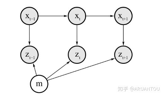
任何占用栅格建图的黄金法则都是给定数据计算地图的后验概率
我们可以发现,地图的构建就是寻找判断是否是障碍物,这样就把问题分解成为了一个二值概率的问题,讨论过这个问题的一个滤波器——二值贝叶斯滤波器binary Bayes filter。

occupancy grid mapping伪代码:
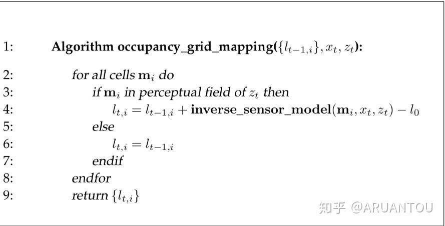
原理还是很简单的,就是遍历所有的网格,判断当前网格cell是否在传感器的扫描范围内,如果在的话,根据 和
来计算对数差异。
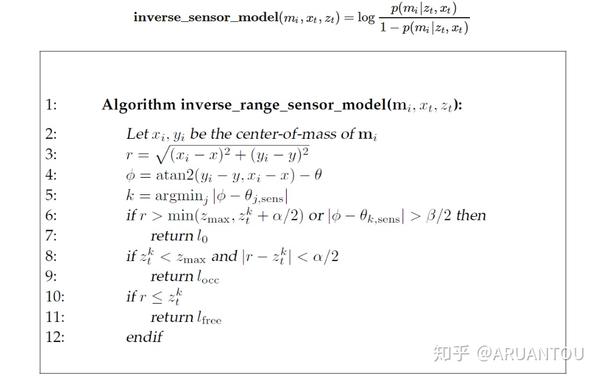
对数差异的逆模型的算法:
这样通过不断的获取扫描的传感器信息和机器人的位姿信息,就可以更新差异值。然后就可以计算 来获取最终的后验概率。
main.cpp
#include <iostream>
#include <math.h>
#include <vector>
using namespace std;

// Sensor characteristic: Min and Max ranges of the beams
double Zmax = 5000, Zmin = 170;
// Defining free cells(lfree), occupied cells(locc), unknown cells(l0) log odds values
double l0 = 0, locc = 0.4, lfree = -0.4;
// Grid dimensions
double gridWidth = 100, gridHeight = 100;
// Map dimensions
double mapWidth = 30000, mapHeight = 15000;
// Robot size with respect to the map
double robotXOffset = mapWidth / 5, robotYOffset = mapHeight / 3;
// Defining an l vector to store the log odds values of each cell
vector< vector<double> > l(mapWidth/gridWidth, vector<double>(mapHeight/gridHeight));

double inverseSensorModel(double x, double y, double theta, double xi, double yi, double sensorData[])
{
    //******************Code the Inverse Sensor Model Algorithm**********************//
    // Defining Sensor Characteristics
    double Zk, thetaK, sensorTheta;
    double minDelta = -1;
    double alpha = 200, beta = 20;

    //******************Compute r and phi**********************//
    double r = sqrt(pow(xi - x, 2) + pow(yi - y, 2));
    double phi = atan2(yi - y, xi - x) - theta;

    //Scaling Measurement to [-90 -37.5 -22.5 -7.5 7.5 22.5 37.5 90]
    for (int i = 0; i < 8; i++) {
        if (i == 0) {
            sensorTheta = -90 * (M_PI / 180);
        }
        else if (i == 1) {
            sensorTheta = -37.5 * (M_PI / 180);
        }
        else if (i == 6) {
            sensorTheta = 37.5 * (M_PI / 180);
        }
        else if (i == 7) {
            sensorTheta = 90 * (M_PI / 180);
        }
        else {
            sensorTheta = (-37.5 + (i - 1) * 15) * (M_PI / 180);
        }

        if (fabs(phi - sensorTheta) < minDelta || minDelta == -1) {
            Zk = sensorData[i];
            thetaK = sensorTheta;
            minDelta = fabs(phi - sensorTheta);
        }
    }

    //******************Evaluate the three cases**********************//
    if (r > min((double)Zmax, Zk + alpha / 2) || fabs(phi - thetaK) > beta / 2 || Zk > Zmax || Zk < Zmin) {
        return l0;
    }
    else if (Zk < Zmax && fabs(r - Zk) < alpha / 2) {
        return locc;
    }
    else if (r <= Zk) {
        return lfree;
    }
}

void occupancyGridMapping(double Robotx, double Roboty, double Robottheta, double sensorData[])
{
    for (int x = 0; x < mapWidth / gridWidth; x++) {
        for (int y = 0; y < mapHeight / gridHeight; y++) {
            double xi = x * gridWidth + gridWidth / 2 - robotXOffset;
            double yi = -(y * gridHeight + gridHeight / 2) + robotYOffset;
            if (sqrt(pow(xi - Robotx, 2) + pow(yi - Roboty, 2)) <= Zmax) {
                l[x][y] = l[x][y] + inverseSensorModel(Robotx, Roboty, Robottheta, xi, yi, sensorData) - l0;
            }
        }
    }
}

int main()
{
    double timeStamp;
    double measurementData[8];
    double robotX, robotY, robotTheta;

    FILE* posesFile = fopen("poses.txt", "r");
    FILE* measurementFile = fopen("measurement.txt", "r");

    // Scanning the files and retrieving measurement and poses at each timestamp
    while (fscanf(posesFile, "%lf %lf %lf %lf", &timeStamp, &robotX, &robotY, &robotTheta) != EOF) {
        fscanf(measurementFile, "%lf", &timeStamp);
        for (int i = 0; i < 8; i++) {
            fscanf(measurementFile, "%lf", &measurementData[i]);
        }
        occupancyGridMapping(robotX, robotY, (robotTheta / 10) * (M_PI / 180), measurementData);
    }

    // Displaying the map
    for (int x = 0; x < mapWidth / gridWidth; x++) {
        for (int y = 0; y < mapHeight / gridHeight; y++) {
            cout << l[x][y] << " ";
        }
    }

    return 0;
}
github:
https://github.com/horo2016/Occupancy-Grid-Mapping-Algorithm